Hi, I’m Nala. Labrador, somewhere in the middle of life, I live with Lutz at Mas Luna in Alforja. When he sets the hiking boots by the door in the morning, I can smell it — stone, pine, a trace of salt from the last walk — and I know what’s about to happen.
Today I’m taking you along on my five favourite routes in the Montanyes de Prades, the range behind our house. They’re different walks for different days: one for the heat, one for the cool mornings, one for the days I want to really run, and two for everything in between.
Lutz usually writes the long pieces on masluna.es. Today I’m having a go, because honestly I know these paths better than he does — he reads the map, I follow what my nose tells me.
Before we head out
Three things to know in advance if you’re bringing your own dog.
Water. The springs that show up in walking guides aren’t reliable every year. Late in summer, almost never. Lutz brings an extra bottle for me, plus a travel bowl. Half a litre per hour for me, plus reserve.
Sheep and Mastíns. The Mastín livestock guardians that live with the flocks up here aren’t a cautionary tale from a guidebook — they’re real. I’ve met a few. They’re professionals; they defend the flock not because they’re aggressive but because that’s the job. When we see them, Lutz puts me on the leash, we walk past at the edge, never between sheep and Mastín. It works. I still think it’s better to be polite than to play hero.
Hot ground. In summer the rock in the sun gets hot enough to hurt my paws. Lutz’s rule of thumb: if he can hold his palm to the ground for five seconds, it’s fine for me. If not, we go early or we don’t go.
Right, the routes.
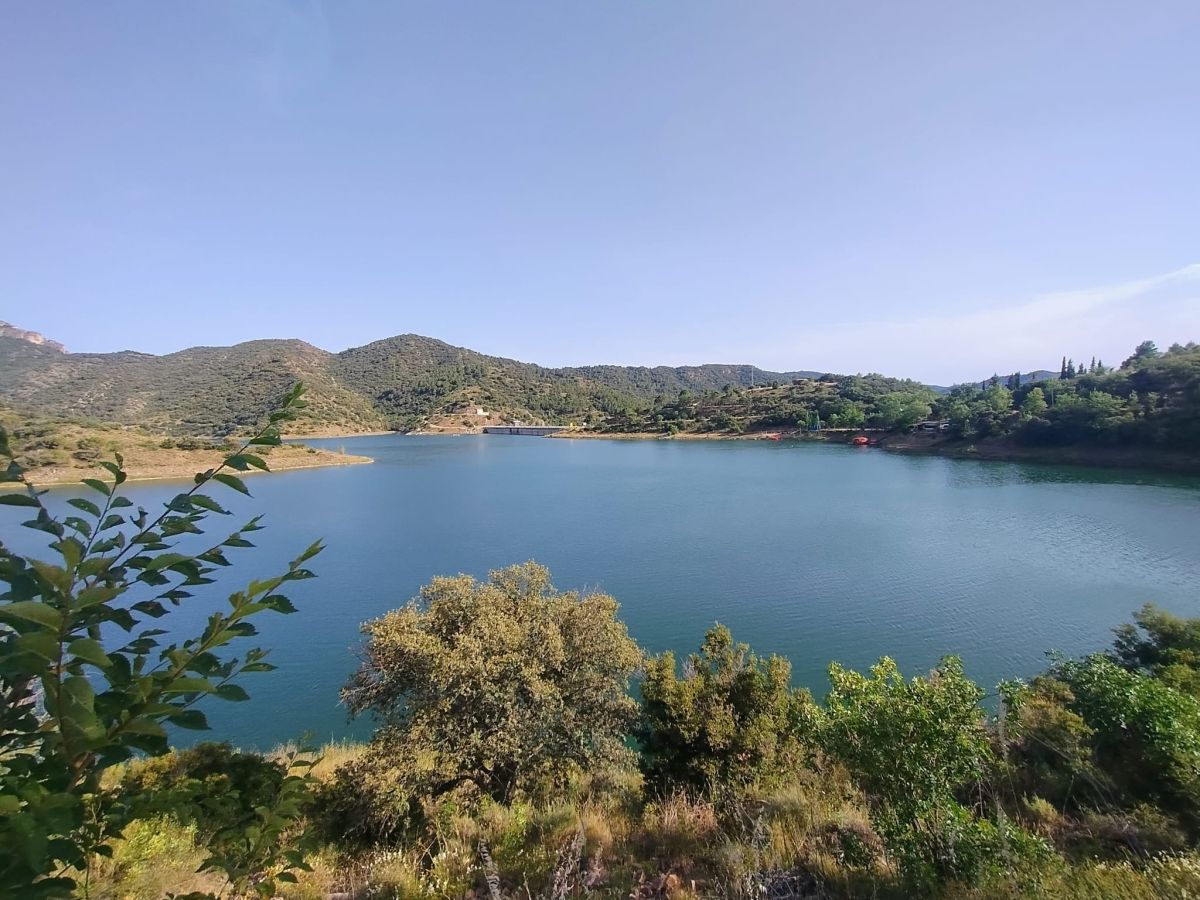
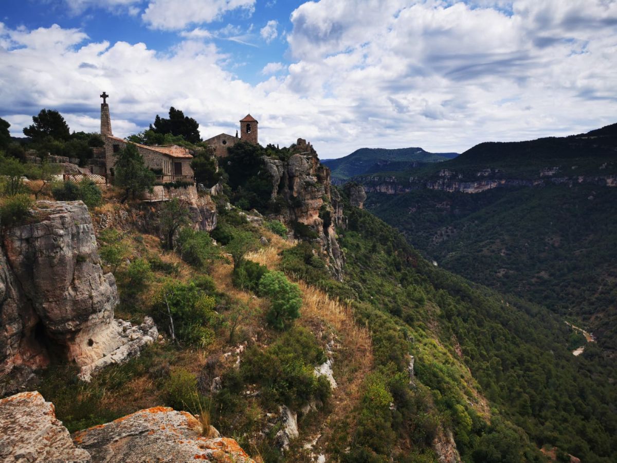
Route 1 — Siurana: the rock village, the classic photo
Distance: about 5.5 km loop · Elevation: 200 m · Duration: 2 to 2.5 hours · Difficulty: easy to moderate
Siurana is the village everyone photographs when they come to the area. Twenty houses on a cliff edge, the ruin of an old castle next door, history that Lutz can tell you better than I can. What interests me: the wind at the Mirador, the smell of cheese from the bar on the plaza, and the path that goes down past the Capella and back up through open holm-oak woodland to the village.
The ground is mostly firm — stone, some earth. The climb back up to the village sits in the sun in summer, so either start early or hang around in the village until the light is lower.
What I like about Siurana: the view of the reservoir. The Embassament glows turquoise in a way no other puddle in the area does. Lutz says it has to do with the slate. I trust him.
Route 2 — La Mussara: the abandoned village on the high plateau
Distance: about 9 km loop · Elevation: 200 m · Duration: 3 hours · Difficulty: easy
La Mussara has been empty since 1959. What’s left — a bell tower, a few crumbling walls — sits on a high plateau just under 1,000 metres. People tell stories of hikers vanishing in the fog. I think it’s a lot of fog and not much supernatural, but fine, it keeps people alert.
For me, La Mussara is the summer route. While Alforja is over thirty degrees in the valley, up here a wind cuts through that makes high summer bearable. The loop from the Refugi La Mussara crosses open plateau, past karst outcrops. On clear days you can see all the way to the Mediterranean.
Not much shade up there, so don’t forget the water, and the ground is rocky — not great for very sensitive paws in the midday heat. I like to walk this one late morning, when the rock hasn’t fully heated up yet.
Route 3 — Mont-ral and the Salt del Cigne
Distance: about 10 km loop · Elevation: 400 m · Duration: 4 hours · Difficulty: moderate
From the village of Mont-ral comes the prettiest stream day in the range. Path drops through dense forest to small pools, then climbs to the Salt del Cigne, a waterfall that’s at its most striking after rain. In high summer it sometimes shrinks to a trickle, so spring and autumn are best.
This route is ideal for me for two reasons. One: shade everywhere — dense forest keeps the heat out. Two: stream crossings. I like walking through water. Lutz calls every time, asking me not to walk the whole length of the stream, follow the dry stones. I hear him. I take the stream.
The village of Mont-ral itself — stone houses, a bar across from the church — is a good start and a good end. We park there, and at the end I always sniff briefly after the dogs lying under the tables.
Route 4 — La Mola de Colldejou: short, steep, the rooftop
Distance: about 7 km loop · Elevation: 600 m · Duration: 4 hours · Difficulty: hard
Honestly? This one’s the toughest of the five. A table-top mountain with near-vertical flanks. From the village of Colldejou the climb pushes up steeply with few breaks, the ground is scree, and just below the plateau there’s a short slightly exposed bit. Lutz sweats here every time.
I do too — I just don’t have a shirt to change into.
The reward at the top: a 360-degree panorama. On clear days you can see the Mediterranean to the south and the foothills of the Pyrenees to the north — or rather, Lutz says he can. I mostly see grass up there and I’m happy to stretch out.
Important: not for very hot days, almost no shade, the climb doesn’t forgive. Not for older dogs with sensitive paws either — the scree is sharp. If you’re fit and start early, you have one of the most rewarding mornings the area offers.
Route 5 — Capafonts: the waterfall stroll
Distance: about 5 km loop · Elevation: 150 m · Duration: 2 hours · Difficulty: easy
This one is my favourite. I’m not saying that to be polite — I’m saying it because on summer days I almost get out of the car before Lutz does.
From the village of Capafonts a short, almost continuously shaded path follows the Brugent river through a narrow valley. Several small pools along the way, a waterfall at the end you can walk into. Family-friendly, no real elevation, no technical sections.
The ground here is cool — damp earth, moss on the stones, water never far. In summer locals come to swim, so morning is quieter. I dip my paws in every pool and check whether the water is fit to drink. (Some yes, some no.)
What works with me — and what to keep in mind
Leash. I prefer off-leash, but wherever sheep flocks are possible — on the open plateau in summer, basically everywhere — I’m on the leash. A leash tells the Mastín “no conflict needed”. Lutz and I learned that this is easier than sorting out trust on the first try.
Water on board. Half a litre per hour per dog, plus a travel bowl. I drink from streams when the water is clear, but on the plateau there are no streams.
Paws. If the ground in summer is too hot in the sun, you stay low or go early. Paw pads heal slowly.
Mas Luna as base camp
Alforja sits right at the foot of the Prades range. Capafonts and Mont-ral are 25 minutes away, Siurana 35, La Mussara and La Mola de Colldejou 30 to 45. Lutz puts the boots by the door at night, I sniff them briefly, then I sleep in my spot, and the next morning we’re in the first stretch of forest before other guests have sat down to breakfast.
If there’s a route you want to ask about that isn’t on this list — I know more. Lutz too. Write to us.
— Nala